


Where Exactly Is the Columbia Way Corridor?
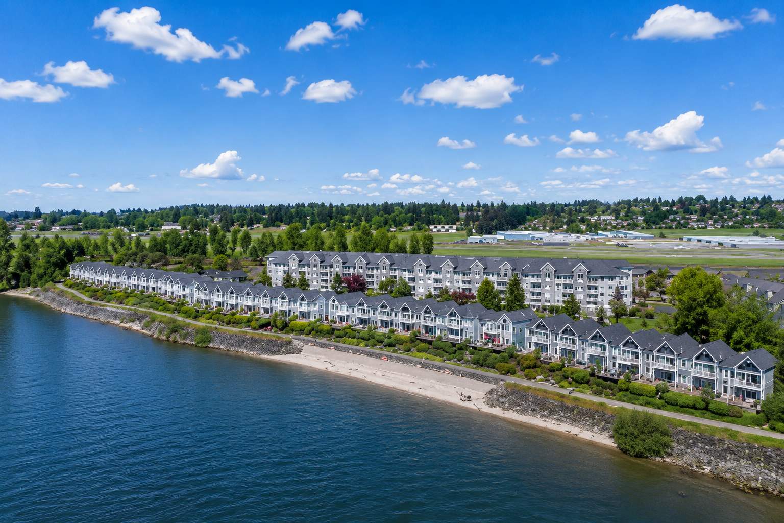
Columbia Way is a waterfront boulevard within the city of Vancouver, Washington, running along the Columbia River's north bank through the southern edge of Vancouver's urban fabric — connecting the revitalized downtown Vancouver waterfront commercial development to the east with the northwest Vancouver industrial and natural river corridor to the west. The road follows the river's north bank through the Vancouver waterfront's most dynamic and most actively developed section, passing through and adjacent to the Columbia River Renaissance Trail's esplanade infrastructure, the Vancouver waterfront's restaurant and retail development, the waterfront park and event spaces, and the mixed-use residential and commercial development that the downtown Vancouver waterfront revival has concentrated along the river's north bank over the last decade and a half.
The residential development associated with the Columbia Way corridor reflects the waterfront revival's investment in mixed-use residential density along the Columbia River's most commercially activated north bank section — primarily condominium and townhome configurations in the newer mixed-use developments that have brought residential occupancy to the waterfront's edge, alongside the occasional single-family residential property in the adjacent residential fabric that approaches the waterfront corridor from the north. The residential character is more urban, more vertical, and more mixed-use integrated than any other Vancouver neighborhood addressed in this content series — reflecting the downtown waterfront development's planning approach that has concentrated residential density alongside commercial activity and public waterfront space rather than separating the residential fabric from the waterfront's commercial energy in the way that conventional suburban residential development consistently does.
The Columbia Way corridor's residential addresses carry the most direct Columbia River waterfront positioning available from any Vancouver residential address — the river's immediate presence visible from primary living spaces, audible in the working commercial vessel traffic that navigates the Columbia's main channel, and experientially immediate in the way that living on a major Pacific Northwest river's bank rather than adjacent to or near it produces for the residents who chose the waterfront address for exactly that reason. That immediacy is both the Columbia Way residential address's most specific and most irreplaceable asset, and the most honestly stated contextual distinction between the Columbia Way waterfront residential experience and the residential communities addressed elsewhere in this Vancouver neighborhood content series.
The Columbia Way corridor is served by the Vancouver School District — with the specific school assignments for Columbia Way-adjacent residential addresses and the magnet, specialty, and focus program options available within the district's offerings worth researching specifically for any family buyer whose purchase decision involves the school district assignment alongside the waterfront residential access.
Portland International Airport is approximately 8 to 13 miles from the Columbia Way corridor, typically a 14 to 22 minute drive depending on traffic, time of day, and your specific route across the Columbia River and east toward PDX. The downtown Vancouver waterfront position gives Columbia Way corridor residents access to the I-5 bridge crossing immediately adjacent to the waterfront's eastern residential development — connecting directly to the I-5 southbound corridor and the airport approach via I-205 east with the most immediate I-5 bridge access available from any Vancouver residential address. For frequent travelers and households where PDX access is a meaningful daily quality-of-life factor, the Columbia Way corridor's waterfront position and its immediate I-5 bridge adjacency deliver the most efficient airport commute available from any Vancouver city address — the bridge crossing's proximity to the waterfront residential development producing a PDX commute that reflects the Columbia River's function as both the geographic boundary between the two states and the most direct routing infrastructure between the downtown Vancouver waterfront and the Portland international airport.
What Your Money Gets You: Homes at Every Price Point
The Columbia Way corridor's residential market reflects the waterfront revival's investment in mixed-use residential density and the specific premium that direct Columbia River waterfront positioning commands in any Pacific Northwest residential market where the combination of river view, river presence, and waterfront esplanade access is available from a residential address rather than approximated from a residential community adjacent to a waterfront park. The residential inventory is primarily the newer condominium and townhome development that the downtown Vancouver waterfront revival has produced along the river's north bank — vertical, urban, and mixed-use in character rather than the mid-century single-family residential fabric that dominates the other Vancouver neighborhood guides in this content series. That vertical, mixed-use character produces the evaluation framework appropriate to an urban condominium and mixed-use residential market rather than the mid-century single-family residential stock's condition variability that defines the broader Vancouver neighborhood residential content.
Here is a realistic look at what different price points deliver in this market:
$325,000 – $475,000
Entry-level Columbia Way corridor residential ownership delivers primarily the smaller condominium and townhome configurations in the waterfront-adjacent residential developments — studio to one-bedroom units in the mixed-use waterfront buildings, two-bedroom configurations in the urban residential developments approaching the waterfront from the north, and in some cases the smaller residential properties in the older residential fabric immediately adjacent to the waterfront corridor's northern boundary. Finishes at this price point reflect the building's construction era and the ownership history of the specific unit — some condominiums in this range have been updated by owners who invested in their waterfront address, others reflect original construction finishes that have held up with normal use. The Columbia River's immediate presence — the river visible from the living room, the esplanade's walking culture accessible from the building's ground floor, the working commercial traffic of the Columbia's main channel audible and visible through the primary living space's windows — is fully present at this price point regardless of the unit's interior finish level or the specific building's construction vintage. HOA fees for waterfront condominium units vary by building age and amenity level and are a real and recurring total ownership cost component that the purchase price comparison does not independently capture. For buyers whose primary criterion is the most financially accessible entry into direct Columbia River waterfront residential living from a Vancouver, Washington address — the specific daily river presence, the esplanade walkability, the downtown Vancouver waterfront's cultural and commercial assets as a neighborhood infrastructure, and the no-Oregon-income-tax financial structure — this range delivers that access at a price that Portland's comparable waterfront residential addresses stopped producing for comparable river presence and comparable walkable waterfront commercial access many market cycles before the Clark County financial advantage made the cross-river comparison genuinely worth running.
$475,000 – $650,000
This is the most active and most revealing price band in the Columbia Way corridor residential market — the range where the waterfront residential proposition's full value becomes most clearly legible and where buyers who have run the honest Portland Pearl District and South Waterfront comparison against the Vancouver waterfront residential market tend to arrive with conviction. Units and properties in this range tend to be updated or well-positioned residential configurations with meaningful Columbia River presence — two-bedroom condominiums in well-located waterfront buildings with river views from primary living spaces and outdoor terraces, townhome configurations with their own ground-floor outdoor spaces and esplanade proximity, and in some cases single-family residential properties in the adjacent residential fabric whose positioning delivers the waterfront corridor's character at the residential scale rather than the condominium density. The Columbia River view orientation, the esplanade walkability, the downtown Vancouver waterfront dining and commercial culture as a daily neighborhood infrastructure, and the I-5 bridge's immediate proximity for PDX and Portland access are all fully present at this price point — and for buyers whose waterfront residential criteria require meaningful river view quality and functional esplanade access alongside the unit's interior quality and the building's HOA financial health, this range delivers the clearest and most complete version of the Columbia Way waterfront residential proposition.
$650,000 – $875,000
At this level, the Columbia Way corridor delivers its most compelling residential product — the two-bedroom and larger condominium and townhome configurations in the waterfront buildings with the most commanding Columbia River view corridors, the most direct esplanade access, and the finish quality that reflects genuine investment in a waterfront residential address rather than the entry-level condominium market's cost-optimization. Primary living spaces with unobstructed Columbia River views, outdoor terraces or balconies oriented toward the river's main channel with Mount Hood visible on the Oregon horizon on clear days, and finish packages that reflect the waterfront premium's investment expectation rather than contradicting it — these are the properties where the Columbia Way waterfront residential experience is most fully and most specifically expressed, and where the daily residential quality of living immediately on the Columbia River's north bank is most completely realized. HOA financial health assessment is as important at this price point as the unit's interior quality — the building's reserve fund adequacy, the management quality, and the special assessment history deserve the same pre-purchase scrutiny that the unit's finish level and its river view orientation receive during a showing.
$875,000 – $1,200,000
The upper end of the Columbia Way corridor residential market delivers the most exceptional waterfront condominium configurations and the most distinguished townhome and mixed-use residential properties along the Columbia River's north bank — full-floor or penthouse configurations in the waterfront buildings with the most commanding and most unobstructed Columbia River view corridors, the most direct and most private esplanade access, and the finish quality, the building amenity level, and the outdoor terrace design that reflects a deliberate and specific investment in the waterfront residential experience at its most complete. The Columbia River's full visual presence from the primary living spaces and outdoor terraces — the Mount Hood and Mount St. Helens sightlines on the Oregon and Washington horizons, the working commercial traffic of the river's main channel, the Vancouver waterfront's cultural programming visible below from elevated positions, and the Pacific Northwest's most defining river as the daily visual and sensory context of residential life — is most fully expressed at this tier. These properties attract buyers who have been specific about wanting the most complete Columbia River waterfront residential experience available from a Vancouver, Washington address, and they move to buyers who were already prepared.
$1,200,000 and above
The highest tier of the Columbia Way corridor residential market is defined by the most exceptional and most uniquely positioned waterfront residential properties — the penthouse configurations with panoramic Columbia River view corridors extending in both directions along the river's course, the custom waterfront residential properties on the corridor's most distinguished sites, and the mixed-use residential developments' premier units where the combination of view quality, outdoor terrace scale, finish excellence, and waterfront positioning makes them genuinely distinctive within the broader Pacific Northwest waterfront residential landscape. These properties surface infrequently, attract buyers whose Columbia River waterfront residential criteria are specific enough to recognize the right property without deliberation, and move to buyers who were already connected, prepared, and committed.
Median residential price in the Columbia Way corridor: The median in the Columbia Way-adjacent residential market sits in the $480,000 to $580,000 range when the full inventory — waterfront condominiums, townhomes, and adjacent residential properties — is considered as a whole. That figure positions the Columbia Way corridor as meaningfully more accessible than Portland's Pearl District, the South Waterfront, and the comparable Willamette River-adjacent residential markets on the Oregon side of the bridge at equivalent river presence and equivalent waterfront esplanade access — a price differential that reflects the Washington State financial structure's no-Oregon-income-tax advantage, the Vancouver waterfront's still-completing discovery arc relative to the Portland urban waterfront markets' more established premium, and the honest assessment that the Columbia River's north bank waterfront residential experience from a Vancouver address is genuinely equivalent to, and in some waterfront character respects more directly working-river authentic than, the Portland Willamette River waterfront residential experience that the Oregon side's most recognized waterfront addresses deliver at significantly higher price points.
What About Renting in This Area?
The Columbia Way corridor rental market is more active than most Vancouver neighborhood markets addressed in this content series — reflecting the waterfront revival's mixed-use residential development's intentional inclusion of rental configurations alongside owner-occupied units, the downtown Vancouver employment and hospitality workforce's demand for walkable waterfront proximity, and the Portland-employed professional demographic's consistent interest in waterfront residential access from a Washington State address that the no-Oregon-income-tax advantage makes financially compelling at the waterfront's rental price points.
Studio and one-bedroom waterfront-adjacent rental units typically run between $1,500 and $2,100 per month depending on building quality, floor level, river view orientation, unit size, and the specific waterfront position that determines whether the river is a view from the building's common areas or a direct view from the unit's primary living spaces. Two-bedroom configurations run $2,000 to $3,100 per month depending on square footage, building tier, and the river view quality and esplanade access that distinguishes the waterfront-facing units from the interior-facing configurations in the same buildings. Larger townhome and premium waterfront condominium rentals push into $3,100 and above for configurations with meaningful outdoor waterfront terrace space, direct esplanade access, and the finish quality that the premium waterfront rental market sustains from the Portland-employed professional demographic that the Washington State financial advantage and the waterfront lifestyle consistently attract to the Vancouver waterfront residential market.
Parking in the waterfront development is a separate monthly expense in most buildings — typically $150 to $250 per month for a dedicated space — and the waterfront's esplanade walkability and proximity to the downtown Vancouver's pedestrian infrastructure make car-light or car-free residential life more genuinely practical from the Columbia Way corridor than from any other Vancouver neighborhood address, reducing the parking calculation's significance for households whose daily movement aligns with the waterfront's pedestrian and cycling infrastructure.
Things to Do In and Around Columbia Way
The Columbia Way corridor's defining characteristic as a residential environment is the Columbia River's immediate presence — and from that presence, every outdoor, recreational, cultural, and community activity that life on one of North America's great rivers produces for the residential community embedded within it. The waterfront esplanade, the downtown Vancouver commercial and cultural assets within walking distance, the Columbia River's natural and recreational corridor extending in both directions along the north bank, and the Portland metro's cultural and commercial infrastructure accessible across the bridge together produce a daily life range that no other Clark County residential address replicates from the same river-immediate position.
The Columbia River is the Columbia Way corridor's entire identity — not a view, not a recreational asset requiring a drive, but the working, living, ecologically productive, and visually extraordinary Pacific Northwest river that defines the daily sensory and experiential character of residential life on its north bank in a way that no amount of description adequately communicates before the specific experience of waking up to it every morning makes the case more directly than any real estate content ever will. The river's width at Vancouver, its commercial vessel traffic, its salmon and steelhead fisheries, its migratory bird populations, its tidal dynamics, and its position as the most significant river in the Pacific Northwest's settlement history combine to make the Columbia Way waterfront address the most specifically river-defined residential experience available from any Clark County residential position.
The Vancouver Waterfront Esplanade is the Columbia Way corridor's most immediately walkable community infrastructure — the revitalized public waterfront space that the City of Vancouver's most significant urban investment has produced along the river's north bank, providing the walking and cycling promenade, the restaurant and retail cluster, the event infrastructure, and the riverside park space that give the waterfront residential address its specific daily lifestyle quality. For Columbia Way corridor residents, the esplanade is not a destination requiring a drive — it is the ground-floor extension of the residential address itself, the place where the Tuesday evening walk happens naturally and where the Saturday morning community gathering requires no planning.
Waterfront dining and the Grant Street Pier restaurant cluster — addressed in the downtown Vancouver guide and literally within walking distance of the Columbia Way corridor's residential addresses — is the most directly accessible dining and commercial infrastructure of any Vancouver residential community in this content series. For Columbia Way residents, the waterfront's restaurant cluster is the neighborhood dining district in the most literal sense — the restaurants facing the Columbia River are accessible on foot from the residential address without a car, without a parking commitment, and without the planned-outing character that most Vancouver residential communities require for comparable dining access.
The Columbia River Renaissance Trail runs directly along the Columbia Way corridor — providing the paved multi-use path infrastructure that connects the waterfront residential community to the Columbia River's north bank trail network in both directions, eastward toward the I-5 bridge and the Marine Drive trail connection to Portland's north waterfront parks, and westward toward the northwest Vancouver natural river corridor and the Fruit Valley waterfront area's more natural and less commercially developed river character. For Columbia Way residents whose daily outdoor practice includes waterfront walking and cycling, the Renaissance Trail is the most directly and most completely accessible multi-use trail infrastructure of any Vancouver residential community in the content series.
Fort Vancouver National Historic Site and the Pearson Air Museum — accessible on foot or by short bicycle ride east from the Columbia Way corridor via the waterfront trail and the McLoughlin Boulevard corridor — provide the nationally significant historical and interpretive programming that gives the downtown Vancouver waterfront residential community its most specific historical depth. For Columbia Way corridor residents, the Fort Vancouver site and the Pearson Field museum are neighborhood institutions in the most practical sense — accessible from the residential address on a Tuesday afternoon without planning or parking commitment.
Officers Row and the McLoughlin Boulevard historical corridor — accessible on foot or by bicycle from the Columbia Way corridor's eastern residential development — provide the historically distinguished Victorian residential streetscape and the historical corridor character that gives the downtown Vancouver waterfront residential community its most direct connection to the Pacific Northwest settlement history that the inner Vancouver neighborhood landscape carries as a matter of residential fact.
The Columbia River's fishing access — the salmon and steelhead fisheries, the sturgeon fishing, and the working river's recreational angling culture that the Columbia's north bank provides from the waterfront corridor's fishing access points — gives Columbia Way corridor residents the most directly accessible Columbia River fishing of any Vancouver residential address in this content series. For serious Columbia River anglers whose residential criteria include the most direct waterfront fishing access available from a city-of-Vancouver address, the Columbia Way corridor's north bank position delivers that access within the residential range rather than requiring a drive to a downstream access point.
Sauvie Island — accessible approximately 15 to 20 minutes south and west via the I-5 bridge and the Sauvie Island Bridge approach — provides the Columbia River island agricultural and wildlife refuge experience that the northwest Columbia River corridor's geographic position makes specifically accessible from the Columbia Way waterfront address. For Columbia Way residents whose recreational life includes the Sauvie Island farm stands, the wildlife refuge bird watching, and the Columbia River beaches, the waterfront corridor's proximity to the I-5 bridge approach makes the Sauvie Island outing a casual afternoon commitment rather than a planned excursion.
The Columbia River's east-west waterfront trail extension — the Marine Drive trail on the Portland Oregon side of the river, accessible via the pedestrian-cycling crossing of the Columbia River at the historic Railroad Bridge's pedestrian access — connects the Columbia Way waterfront esplanade to Portland's north waterfront parks and the Marine Drive trail's east-west Columbia River corridor without requiring a car or a bridge approach via the interstate crossings. For Columbia Way corridor residents whose outdoor recreation includes cross-river cycling or walking, the pedestrian bridge crossing connects the Vancouver waterfront directly to Portland's north waterfront infrastructure in a way that no other Vancouver residential address provides with the same immediate and car-free accessibility.
The Columbia River Gorge — 25 to 35 minutes east via I-205 — is accessible from the Columbia Way corridor via the Columbia Way eastward approach to I-205, providing the world-class outdoor recreation corridor's western entry within a drive that reflects the downtown Vancouver waterfront position's direct I-205 approach without the inner Vancouver residential navigation that the more northern Vancouver communities navigate before reaching comparable freeway access.
Portland is across the I-5 bridge — accessible from the Columbia Way corridor's eastern waterfront development via the waterfront approach to the I-5 crossing in one of the shortest and most direct Portland commutes available from any established Vancouver residential address. The I-5 bridge's immediate proximity to the Columbia Way corridor's eastern residential development produces a Portland commute that most Columbia Way residents describe as the most seamless cross-river transition available from any Clark County residential address — the waterfront routing to the bridge connecting directly without navigation through the downtown Vancouver arterial grid, and the bridge crossing delivering downtown Portland, the Pearl District, and the Northwest District's commercial and cultural infrastructure within a commute that the waterfront proximity and the I-5 bridge adjacency combine to produce at the shortest drive time available from any Vancouver city address.
Where to Eat
The Columbia Way corridor's dining scene is its most immediately compelling daily lifestyle asset — the waterfront esplanade's restaurant cluster and the downtown Vancouver Main Street independent restaurant corridor together producing the most directly walkable dining infrastructure of any residential address in the Vancouver neighborhood content series. From the Columbia Way corridor's residential addresses, the restaurant scene is not a commercial destination requiring a car or a planned outing — it is the ground-level infrastructure of the waterfront neighborhood, accessible on foot with the same casual frequency that urban neighborhood restaurants serve their most walkably positioned residential customers when the distance between the front door and the table is measured in blocks rather than miles.
Beaches Restaurant and Bar — the Columbia River waterfront institution whose casual, scenic, and reliably excellent dining on the river's north bank has built decades of resident and visitor loyalty — is among the most directly accessible destination restaurants from the Columbia Way corridor's residential addresses, with the waterfront positioning that makes the walk from the residential building to the restaurant the simplest dining commute available from any Vancouver residential address. The outdoor patio's Columbia River orientation on a clear Pacific Northwest evening with Mount Hood visible on the Oregon horizon is the specific waterfront dining experience that Portland's Willamette River restaurants approximate from the Oregon side and that the Columbia Way corridor's Vancouver waterfront delivers from the Washington side at price points that the Oregon waterfront restaurant market has not sustained for comparable river orientation quality in many years.
The Grant Street Pier and Vancouver Waterfront restaurant cluster — the collection of waterfront-facing restaurants and bars that the downtown Vancouver waterfront revival's commercial development has concentrated along the esplanade — is the Columbia Way corridor residential community's most immediately accessible dining ecosystem and the most directly river-adjacent dining infrastructure available from any Vancouver residential address. The restaurant cluster's river-facing outdoor seating, the Columbia River's immediate visual presence from the dining rooms and terraces, and the esplanade's pedestrian culture that animates the waterfront's restaurant environment throughout the day and into the evening give the Columbia Way waterfront residential address a dining culture that is specifically and genuinely embedded in the river's north bank character rather than serving the waterfront as a commercial backdrop.
The downtown Vancouver Main Street independent restaurant corridor — accessible on foot or by short bicycle ride east along the waterfront trail and the Columbia Way approach to the downtown commercial streets — provides the independent restaurant culture, the craft beer taproom scene, and the community-invested commercial dining character that the downtown Vancouver guide addressed. For Columbia Way corridor residents, the Main Street restaurant corridor is a walking dining destination in the most practical sense — the dinner at the Grocery, the cocktail at a downtown bar, and the post-dinner walk back along the esplanade constituting the kind of pedestrian urban dining circuit that Pacific Northwest waterfront residential communities aspire to produce and that the Columbia Way corridor delivers with a completeness that distinguishes it from every other Vancouver neighborhood in this content series.
The Uptown Village NE Broadway independent restaurant and craft beer corridor — approximately 10 to 15 minutes by bicycle or 8 to 12 minutes by car from the Columbia Way corridor — provides the Uptown Village's community-invested commercial dining culture as a practical cycling or driving extension of the waterfront dining range. For Columbia Way corridor residents whose dining preferences extend beyond the immediate waterfront and downtown commercial infrastructure toward the independent neighborhood restaurant character that the NE Broadway corridor delivers, the esplanade's cycling connectivity to the inner Vancouver neighborhoods makes the Uptown Village dining culture a genuinely accessible extension rather than a committed destination outing.
Portland's full restaurant landscape — across the I-5 bridge in a commute that the Columbia Way corridor's bridge-adjacent positioning makes the most efficiently accessible of any Vancouver city address — provides the Pearl District dining corridor, the NW District restaurant culture, the James Beard-recognized restaurants, and the comprehensive culinary infrastructure of a nationally recognized food city. For Columbia Way corridor residents whose dining ambitions occasionally call for the city's full restaurant depth, the I-5 bridge's walking and cycling accessibility from the waterfront's eastern residential development makes Portland's nearest high-density restaurant corridors as practically accessible as they are from many inner Portland neighborhoods whose proximity to the same restaurants requires navigation through the Portland street grid's own residential fabric rather than a simple bridge crossing from the waterfront's edge.
The honest framing: The Columbia Way corridor delivers the most walkable and the most immediately accessible waterfront dining culture of any Vancouver residential address in this content series — the Grant Street Pier restaurant cluster, the Beaches Restaurant waterfront institution, and the downtown Vancouver Main Street independent restaurant corridor together producing a pedestrian dining range that compensates for the relative residential density and the urban mixed-use character of the waterfront residential address in ways that the mid-century lot culture and the neighborhood quietude of the more suburban Vancouver neighborhoods do not independently provide from their residential fabric's relationship with the commercial corridors that serve them.
Who Buys Along Columbia Way?
After nearly three decades working the Clark County market, the Columbia Way corridor residential buyer is the most specifically river-defined and the most urban-waterfront-culture-organized residential profile in the entire Vancouver neighborhood content series — a buyer whose residential criteria are organized around the Columbia River's immediate daily presence as the defining feature of the residential experience rather than as one outdoor asset among several that the residential address happens to provide within a practical recreational range.
They are Columbia River devotees whose relationship with the Pacific Northwest's defining river is not recreational in the weekend-trip sense but residential in the daily-life sense — buyers who have been living adjacent to the Columbia River in Clark County or Portland's north waterfront communities and who have concluded that the difference between living near the Columbia River and living on the Columbia River's north bank is a residential quality distinction worth the urban mixed-use character, the condominium density, and the waterfront premium that the Columbia Way corridor's most directly river-adjacent addresses command. For these buyers, the waterfront residential address's daily river presence — the morning coffee with the commercial traffic moving through the main channel visible from the living room, the evening walk along the esplanade with the river's working character audible and visual at the waterfront's edge, and the specific sensory richness of a major Pacific Northwest river as the constant and immediate environmental context of residential life — is the organizing residential criterion that the Columbia Way corridor satisfies more completely than any other Vancouver address at any price point.
They are urban waterfront lifestyle buyers whose primary residential criterion is walkable access to a revitalized waterfront commercial and cultural infrastructure alongside the river's immediate presence — buyers for whom the ability to walk to the waterfront restaurant, cycle to the downtown Vancouver Main Street independent commercial corridor, and engage with the Columbia River esplanade's cultural programming without a car defines what urban residential quality actually means rather than what it is aspirationally marketed as from residential addresses that require driving to approximate the same experience. For these buyers, the Columbia Way corridor delivers the most complete version of the urban waterfront lifestyle available from any Clark County residential address — the esplanade's walkability, the restaurant cluster's pedestrian accessibility, and the Columbia River's immediate north bank presence combining to produce a daily residential quality that the broader Vancouver residential market cannot replicate regardless of the commercial investment deployed elsewhere in the city.
They are Portland-to-Vancouver relocation buyers who have run the no-Oregon-income-tax calculation with the fullest financial specificity that their Portland employment income deserves — recognizing that the Columbia Way corridor's waterfront residential proposition, combined with the I-5 bridge's most immediately accessible Vancouver-side approach from the waterfront development, produces the most complete combination of Columbia River waterfront lifestyle, Portland commute efficiency, and Washington State financial advantage available from any Clark County residential address. For these buyers, the Columbia Way corridor is not a compromise between waterfront lifestyle and Portland access — it is the specific combination of both at a price point that the Portland waterfront residential markets on the Oregon side price significantly above for equivalent or lesser river presence and equivalent or lesser pedestrian waterfront lifestyle completeness.
They are downsizers and lifestyle-simplifiers who have spent decades in the Clark County suburban residential landscape — the larger homes, the larger lots, the longer commutes, and the car-dependent commercial access that suburban Clark County residential life consistently requires — and who have concluded that the Columbia Way corridor's condominium density, its walkable waterfront commercial infrastructure, its Columbia River immediate presence, and its dramatically simplified residential footprint represent the most specifically satisfying residential trade available in Clark County for the household that is ready to exchange the suburban residential scale for the urban waterfront experience. For these buyers, the Columbia Way corridor delivers the residential simplification they came looking for at a Pacific Northwest river waterfront setting that compensates more than adequately for the square footage and the lot culture that the suburban residential experience provided for the decades of ownership tenure that preceded the waterfront move.
They are buyers from Portland's Pearl District and South Waterfront whose equity from the Oregon side's recognized urban waterfront residential markets has compounded to a level where the Washington State financial structure's no-Oregon-income-tax advantage — real and significant at the income levels that Pearl District and South Waterfront residential tenure implies — makes the Columbia River's north bank waterfront residential experience from a Vancouver address the most financially complete version of the Pacific Northwest urban waterfront lifestyle available within the Portland metro's accessible range. These buyers understand what urban waterfront residential quality means from their prior Portland waterfront experience, and they find the Columbia Way corridor's Vancouver waterfront residential product equivalent or superior in direct river presence and lower in absolute residential cost, the combination producing a purchase decision that the honest Portland waterfront versus Vancouver waterfront comparison consistently supports when the financial structure's advantage is factored into the total residential cost calculation.
They are, consistently, buyers who describe the Columbia Way corridor as delivering the most specifically river-present and the most specifically waterfront-complete daily residential experience available from any Clark County address — and who report that the Columbia River's immediate north bank character, experienced as a daily residential reality rather than as an occasional recreational destination, is more specifically enriching and more specifically irreplaceable than any amount of description communicated before the daily residential experience made the case from the living room window on a clear morning with Mount Hood on the horizon and the commercial traffic moving through the main channel below.
What You Should Know Before You Commit
The Columbia Way corridor residential market requires the same building-level due diligence framework that the Pearl District Portland guide addressed earlier in this content series — and for the same structural reasons that apply to any urban condominium and mixed-use waterfront residential market where the building's financial health, the HOA's management quality, and the construction standards of the specific waterfront development matter as directly to the long-term ownership experience as the unit's interior quality and its river view orientation.
HOA financial health and building-level due diligence are the most consequential pre-purchase investigation elements for any Columbia Way corridor condominium or townhome purchase — the waterfront building's reserve fund adequacy, the HOA's special assessment history, the management quality and the responsiveness that the building's operational governance reflects, and the construction standards that the specific waterfront development employed during its construction era all determine the long-term cost of ownership and the resale trajectory of the specific unit more directly than any surface-level showing experience communicates. Requesting and reviewing the HOA financial documents, the reserve study, and the meeting minutes before making an offer is the essential starting point rather than an optional due diligence step for any Columbia Way condominium purchase.
The waterfront development context's ambient character — the Columbia River's commercial vessel traffic noise, the waterfront event infrastructure's seasonal programming activity, the downtown Vancouver esplanade's weekend energy and its weekday quietude, and the working river's industrial adjacency on the northwest waterfront corridor's western approach — varies across the Columbia Way corridor's residential geography in ways that the waterfront lifestyle's aspirational character does not uniformly represent across every residential address. Understanding the specific ambient character of any Columbia Way unit being seriously considered — the noise profile from the river's commercial traffic, the esplanade's event programming proximity, and the specific building's relationship with the working waterfront's industrial infrastructure on the corridor's western section — is the honest pre-purchase assessment that distinguishes buyers who chose the Columbia Way waterfront character deliberately from those who discovered its specific ambient conditions after closing.
The Columbia River's flood zone and tidal dynamic considerations carry the same essential pre-purchase significance for Columbia Way corridor waterfront residential purchases that the Fruit Valley guide addressed for the northwest Vancouver waterfront positions — FEMA flood zone designations, the Columbia River's periodic high-water dynamics, and the tidal influence that the lower Columbia River's proximity to the Pacific produces for the waterfront building's ground-floor and lower-floor residential configurations all affect insurance requirements, financing options for certain loan programs, and the practical land use implications for the most directly waterfront-positioned residential units. Confirming the specific flood zone status for any Columbia Way corridor unit being seriously considered is essential pre-offer due diligence.
Parking considerations at the waterfront development deserve explicit pre-purchase resolution rather than assumption — the waterfront development's parking supply, the specific unit's parking allocation, the cost of dedicated parking within the building or within the waterfront's surface parking infrastructure, and the household's genuine car dependency versus the waterfront's pedestrian and cycling infrastructure's ability to serve the daily movement requirements all factor into the total ownership cost calculation in ways that the unit's purchase price comparison does not independently capture.
The Vancouver School District's specific school assignments for Columbia Way-adjacent residential addresses deserve the specific research that any family buyer's educational priorities require.
Thinking About a Home Along Columbia Way?
Columbia Way corridor inventory at the quality end of the waterfront market — the most directly river-facing units with the most commanding view corridors and the most complete esplanade access, in buildings with the strongest HOA financial profiles and the highest construction quality — moves with the momentum that genuine Columbia River waterfront presence, esplanade walkability, I-5 bridge proximity, and Washington State financial advantage together create in a buyer pool that knows exactly what it is looking for and recognizes it with conviction when it appears. I have been working the Clark County waterfront market for close to three decades, I know the Columbia Way corridor's residential buildings at the unit level, and I will give you a straight read on what you are looking at — the unit's specific river view orientation, the building's HOA financial health, the flood zone status, the parking situation, the school assignment, and the complete total cost of ownership picture alongside the no-Oregon-income-tax financial calculation — before you write anything.
See more about Columbia Way
Want to learn more about the Columbia Way neighborhood and homes?
Homes for sale in Columbia Way: https://jamiemeushawrealestate.com/properties/neighborhood-Columbia%20Way,%20Vancouver,%20WA/
Watch more local real estate insights on my YouTube channel:
https://www.youtube.com/@JamieMeushaw
Sign up for my weekly newsletter for real estate tips and market updates:
https://jamiemeushawrealestate.com/newsletter
Check out this article next